Angus Glen
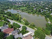
Neighbourhood in Ontario, CanadaAngus Glen is a suburban neighbourhood in the city of Markham. It is roughly bounded by Warden Avenue on the west, Kennedy Road on the east, Sixteenth Avenue on the south, and Major Mackenzie Drive on the north. Developed in the late 1990s, the original Angus Glen East Village, comprising approximately 500 single family homes and townhouses, was planned with the "New Urbanism" concept, to allow for the homes to be designed with the appearance of historic houses, with separate garages on rear laneways. In the mid-2000s the land west of the small creek on the west border of the East Village section commenced development, and is still under construction, known as the West Village. Throughout this period the East Village had a tract of land which had originally been sold to the school board for a possible school. However, the demographic studies could not support a school and after many years of negotiations the developer re-purchased the land in early 2014 and the East Village has had approximately 50 homes under construction, just east of the baseball park and along the north border of York Downs Golf Club. These homes will increase the East Village's homes to close to 600 and the entire community to approximately 1,100.
Read article


.jpg)
Top Questions
AI generatedMore questions
Nearby Places

Cachet, Markham
Neighbourhood in York, Ontario, Canada

Pierre Elliott Trudeau High School
Public school in Markham, Ontario, Canada

Angus Glen Golf Club
Quantztown, Ontario
Unincorporated community in Ontario, Canada

Cashel, Markham
Unincorporated community in Ontario, Canada

Wismer Commons
Neighbourhood in York, Ontario, Canada
Unionville Public School
Elementary school in Markham, ON, Canada
Toogood Pond Park